Перейти к основному содержанию

page search

Displaying 13 - 24 of 342

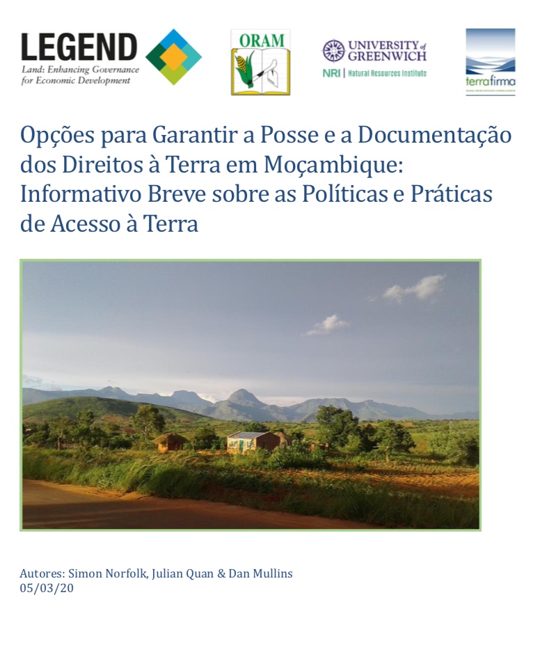
Opções para Garantir a Posse e a Documentação dos Direitos à Terra em Moçambique

Policy Papers & Briefs
февраля, 2020
África Oriental
Moçambique

Um dos principais aspectos do quadro legal moçambicano de terras é que os cidadãos Moçambicanos podem adquirir direitos de posse por herança, por ocupação pacífica ou por canais costumeiros. Estes usufruem de direitos de posse, conhecidos pelo acrônimo em língua portuguesa 'DUAT' (Direito de Uso e Aproveitamento da Terra), que podem ser possuídos individualmente ou em conjunto.

Opções para Garantir a Põsse e a Dõcumentaçaõ dõs Direitõs a Terra em Mõçambique

Policy Papers & Briefs
февраля, 2020
África Oriental
Moçambique

Este documento informativo é baseado nos resultados e lições aprendidas em projectos realizados recentemente em Moçambique, financiados pelo programa LEGEND do DFID, nas análises mais amplas conduzidas por esse programa, e no conhecimento e experiência prática dos autores. O documento é um resumo de um Documento mais longo sobre Política e Práticas de Norfolk, S., Quan, J. & D.

Space-based SAR and optical remote sensing for productivity monitoring and mapping of sugarcane

Reports & Research
февраля, 2020

In this study, research on productivity and land cover monitoring is presented, with a focus on sugarcane, based on space-based remote sensing observations that were collected by Synthetic Aperture Radar (SAR) and optical sensors. The study aims to provide new insights into techniques and methodologies that allow for cost-efficient monitoring of sugarcane productivity and the wide-scale expansion of sugarcane over long time series.

Historical Trajectory in Vegetation Cover in Northeastern Namibia Based on AVHRR Satellite Imagery (1982–2015)

Peer-reviewed publication
ноября, 2019
Namibia
Global

The negative impact of the reduction of vegetation cover is already being felt in the Zambezi Region in northeastern Namibia. The region has been undergoing various land cover changes in the past decades. To understand the historical trend of vegetation cover (increase or decrease), we analyzed 8-km resolution Global Inventory Monitoring and Modeling Studies (GIMMS) from the Advanced Very High Resolution Radiometer (AVHRR) and 0.25° × 0.25° (resampled to 8 km) resolution Global Precipitation Climatology Center (GPCC). We used the Time Series Segmented Residual Trends (TSS-RESTREND) method.

Development Assessment of the Singapore Land

Peer-reviewed publication
июля, 2019
Singapore

Urban indicators plays an important role in the planning and sustainable development of the cities. This paper presents a methodology to determine the favorability index for development of Singapore based on land cover. The ‘City Index’ of Singapore was calculated using five indicators – Social, Environmental, Industrialization, Economic, and Naturality. Two indices ‘Environmental Capacity of Development’ and ‘Land Restriction’ were used as correction factors in the Singapore favorability index for development determination.

Climate, Land Use and Land Cover Changes in the Bandama Basin (Côte D’Ivoire, West Africa) and Incidences on Hydropower Production of the Kossou Dam

Peer-reviewed publication
июля, 2019
Western Africa

Climate and land use/cover changes are potential drivers of change in hydrology and water use. Incidences of these factors on Bandama hydrological basin and Kossou hydropower generation (1981–2016) in West Africa are assessed in this present work. Using Landsat products of United Stated Geological Survey, results show that water bodies areas and land use have increased by 1.89%/year and 11.56%/year respectively, whereas herbaceous savanna, savanna, forest and evergreen forest coverage have been reduced by 1.39%/year, 0.02%/year, 2.39%/year and 3.33%/year respectively from 1988 to 2016.

Monitoring Effects of Land Cover Change on Biophysical Drivers in Rangelands Using Albedo

Peer-reviewed publication
февраля, 2019
Global

This paper explores the relationship between land cover change and albedo, recognized as a regulating ecosystems service. Trends and relationships between land cover change and surface albedo were quantified to characterise catchment water and carbon fluxes, through respectively evapotranspiration (ET) and net primary production (NPP). Moderate resolution imaging spectroradiometer (MODIS) and Landsat satellite data were used to describe trends at catchment and land cover change trajectory level. Peak season albedo was computed to reduce seasonal effects.

Predicting Land Use Changes in Philadelphia Following Green Infrastructure Policies

Peer-reviewed publication
января, 2019
United States of America

Urbanization is a rapid global trend, leading to consequences such as urban heat islands and local flooding. Imminent climate change is predicted to intensify these consequences, forcing cities to rethink common infrastructure practices. One popular method of adaptation is green infrastructure implementation, which has been found to reduce local temperatures and alleviate excess runoff when installed effectively. As cities continue to change and adapt, land use/landcover modeling becomes an important tool for city officials in planning future land usage.

Standardizing land cover mapping for tsetse and trypanosomiasis decision making

Journal Articles & Books
января, 2019
Angola
Mozambique
Egypt
Botswana
Malawi
Rwanda
Mauritania
Somalia
Uganda
Mali
Burundi
Italy
Tanzania
Sudan
Congo
Senegal
Chad
Namibia
Niger
Eritrea
Kenya

The habitat of tsetse fly (Glossina spp.) depends upon climatic conditions, host availability and land cover characteristics. In this paper, the Land Cover Classification System (LCCS), developed by the Food and Agriculture Organization (FAO) and the United Nations Environment Programme (UNEP), is proposed as a tool to harmonize land cover mapping exercises carried out in the context of tsetse and trypanosomiasis (T&T) research and control.

Changes in Land Cover and Urban Sprawl in Ireland From a Comparative Perspective Over 1990–2012

Peer-reviewed publication
января, 2019
Ireland

In this article, we first summarise trends of land use changes and urbanisation in Ireland since 1990 using data from the Corine Land Cover program. In doing so, we compare the developments in Ireland with other European countries. Second, we propose a statistical test for the presence of sprawl using conditional and unconditional convergence tests. The two-part empirical analysis allows us to establish that Ireland has experienced a substantial loss of non-urban land in recent decades.

Machine Learning and Property Rights

Journal Articles & Books
декабря, 2018
Global

An Introduction to Machine Learning

Machine learning is an application of artificial intelligence (AI) that enables systems to programmatically “learn” and improve from past experience. Computers use algorithms and statistical models to “learn” patterns and insights from sample sets of data (often called “training data sets”), and apply those insights to make intelligent predictions and decisions about much larger sets of data.

Improving the accuracy of remotely sensed irrigated areas using post-classification enhancement through UAV [Unmanned Aerial Vehicle] capability

Journal Articles & Books
декабря, 2018
South Africa
Southern Africa

Although advances in remote sensing have enhanced mapping and monitoring of irrigated areas, producing accurate cropping information through satellite image classification remains elusive due to the complexity of landscapes, changes in reflectance of different land-covers, the remote sensing data selected, and image processing methods used, among others. This study extracted agricultural fields in the former homelands of Venda and Gazankulu in Limpopo Province, South Africa.