Перейти к основному содержанию

page search

Displaying 73 - 84 of 171

Eight guide steps for setting up a Climate-Smart Village: A trainer's guide

декабря, 2019
Global

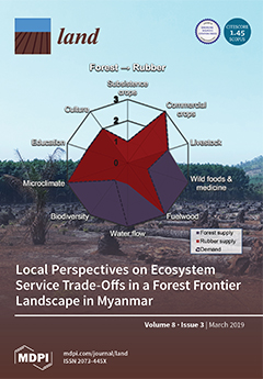
The training manual presents a step-by-step process of establishing a Climate-Smart Village (CSV), with each step being complemented with learning objectives, session guides, and educational support materials. Additional links were provided for each step to promote further learning for its users. Different forms of visuals such as photos, maps, and graphs make the publication easy to read and thus easy to understand. This is almost a one-stop-shop for implementers to acquire the information, capacity, and other prerequisites necessary for establishing a CSV.

Participatory climate risk mapping: Building local adaptation capacities. A case from Ivisan , Capiz , Philippines

декабря, 2019
Philippines

The report discussed how the local government unit in Ivisan municipality, Capiz, Philippines coped with, mitigated, and prepared for climate related risks in the livelihood and agri fisheries sector. The goal of the research was to produce Climate Related Risk Maps and Adaptation Plans in agriculture (Climate Smart MAP/CS MAP) for the 15 villages of Ivisan. The maps will assist in decision making and planning for risks, in normal and severe years, on a long term basis.

Classifying and Mapping Periurban Areas of Rapidly Growing Medium-Sized Sub-Saharan African Cities: A Multi-Method Approach Applied to Tamale, Ghana

Peer-reviewed publication
февраля, 2019
Africa
Ghana

Periurban areas of growing cities in developing countries have been conceptualised as highly dynamic landscapes characterised by a mixture of socioeconomic structures, land uses and functions. While the body of conceptual literature on periurban areas has significantly increased over the past two decades, methods for operationalising these multi-dimensional concepts are rather limited. Yet, information about the location and areal extent of periurban areas is needed for integrated planning in the urban–rural interface.

Land Grabbing for Palm Oil in Sierra Leone: Analysis of the SOCFIN Case from a Human Rights Perspective

января, 2019
Sierra Leone

A 16 minute documentary film developed by ESAFF Uganda detailing how small-scale farming communities in northern Uganda are using LSLBI tools to raise the awareness;especially of women;to engage with local leaders;produce resource maps;including scoping;negotiating;monitoring and implementation. The training also used drama. The aim is to empower farmers who engage with investors.

Application of systematic monitoring and mapping techniques

Journal Articles & Books
сентября, 2018
Eastern Africa
Kenya

Drylands cover over 40% of the earth's surface and support over 2 billion people, globally (Millennium Ecosystem Assessment, 2005). In East Africa alone, over 250 million people depend on drylands for their livelihoods (De Leeuw et al., 2014) and in Kenya, 70% of the total land area is classified as arid- and semi-arid (Batjes, 2004). Over the last several decades, an increasing and more sedentary human population has resulted in more pressure on these lands, and an expansion of agricultural production into marginal dryland areas that were traditionally rangelands.

Large scale GIS mapping recommendation maps for solving land management issues

Multimedia
ноября, 2017
Ukraine
Latvia

The article shows results of compiling recommendation land use maps for land use and land resources management of the university experimental farm “Velykosnitynske”. Large-scale GIS mapping of experimental farms allows to improve land use and decision making, prepare recommendations to solve land management issues, planning of technology processes and efficient crop growing technology. Compiled recommendation maps are aimed to assist in rational land use planning and sustainable development of the territory.

What’s (Not) on the Map: Landscape Features from Participatory Sketch Mapping Differ from Local Categories Used in Language

Peer-reviewed publication
ноября, 2017
Global

Participatory mapping of local land use as the basis for planning and decision-making has become widespread around the globe. However, still relatively little is known about the conceptual underpinnings of geographic information produced through participatory mapping in given cultural and linguistic settings. In this paper, we therefore address the seemingly simple question of what is (not) represented on maps through an exploratory case study comparing land use categories participants represented on sketch maps with categories elicited through more language-focused ethnographic fieldwork.

Overview of AW3Dsup(TM) global 3D map service'3D Maps That You Look at' change to '3D Map That You Can Use'

Journal Articles & Books
октября, 2016
Global

AW3Dsup(TM), the world's most precise global 3D map service, became the world's first five-meter-resolution 3D map covering all global land spaces in April 2016 by using Advanced Land Observing Satellite (ALOS). In addition to five-meter-resolution global map, enhanced service offers a higher-resolution 3D map at half-meter or two-meter resolution, both of which are offered on an on-demand basis using commercial high-resolution satellite imagery. This paper introduces the project history, technical characteristics, service contents, use cases and future prospects of AW3Dsup(TM).

Mapping For Rights Initiative

Websites
ноября, 2011
Global

MappingForRights, an initiative of the Rainforest Foundation UK and local partners, enables forest communities themselves to demonstrate their presence in the forest; decision-makers and the private sector to take account of and recognise this presence; and to assist the international community in ensuring that programmes concerned with the Congo Basin’s forests provide equitable benefits for local communities.

Cadastral maps as a basis for developing street maps: examples from Australia and Brunei

Conference Papers & Reports
октября, 2011
Brunei Darussalam
Australia

Cadastral maps can be used as an effective initial set of data for new street maps in particular, and any type of large scale map project in general. This is due to a) a high degree of currency and accuracy of the digital cadastral database (DCDB); b) DCDB’s overall high level of reliability in terms of completeness; and c) the availability of DCDB to the public. It is within the context of these three notable features that the Australian and Bruneian experiences with DCDB are examined.