
Elsevier is a world-leading provider of information solutions that enhance the performance of science, health, and technology professionals.
All knowledge begins as uncommon—unrecognized, undervalued, and sometimes unaccepted. But with the right perspective, the uncommon can become the exceptional.
That’s why Elsevier is dedicated to making uncommon knowledge, common—through validation, integration, and connection. Between our carefully-curated information databases, smart social networks, intelligent search tools, and thousands of scholarly books and journals, we have a great responsibility and relentless passion for making information actionable.
Members:
Resources
Displaying 26 - 30 of 1605Land-use conflicts between biodiversity conservation and extractive industries in the Peruvian Andes

.
The BonaRes metadata schema for geospatial soil-agricultural research data – Merging INSPIRE and DataCite metadata schemes
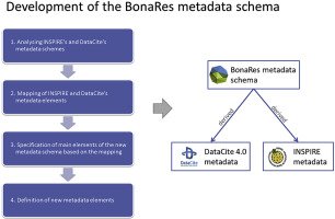
A spatial data infrastructure (SDI) for the upload and provision of soil-agricultural research data in Germany was developed and launched in 2017. The precondition for the new SDI were to be compliant with the European initiative for spatial information (INSPIRE), to consider FAIR data principles, to be interoperable with other disciplinary national and international SDIs and to support dataset registrations with digital object identifiers (DOI). To meet these requirements, the new SDI had to support both the INSPIRE and DataCite metadata standards.
Grey areas in green grabbing : subtle and indirect interconnections between climate change politics and land grabs and their implications for research

Climate change and green grabbing/resource grabbing together call for nuanced understanding of governance imperatives, and for constructing a knowledge base appropriate to political intervention. This paper offers preliminary ways in which interconnections can be seen and understood, and their implications for research and politics explored. It concludes by way of a preliminary discussion of the notion of ‘agrarian climate justice’ as a possible framework for formal governance or political activism relevant to tackling grey area interconnections.
Armed conflict and mining induced land-use transition in northern Nimba County, Liberia
This study determined pre-conflict, conflict and post-conflict land use change and analysed the impact of armed conflict on the intensity of land use change in northern Nimba County. Landsat images of 1986, 1990, 2002 and 2016 were classif
Trade-offs between food security and forest exploitation by mestizo households in Ucayali, Peruvian Amazon