Urban-hinterland water transactions: A scoping study of six class I Indian cities

Conference Papers & Reports
december, 2004
India
Southern Asia

Nieuwe bebouwing tast de openheid van het landschap aan en verlaagt de belevingswaarde. Op basis van berekeningen en veldwaarnemeningen is vastgesteld dat het areaal aan zogenaamde ¿zeer open gebieden¿ tussen 1989 en 2000 met 4% is afgenomen. De toekomstige bedreiging is in hoge mate afhankelijk van de mate van spreiding. Bij 50% meer spreiding dan tussen 1989 en 2000 is het effect twee keer zo groot.
The southern and central regions of The Netherlands are part of the Northwest- European Delta Metropolis. The demands placed by modern, urban society on the agricultural sector are numerous. Not only are the environment, animal welfare, and food hygiene and quality at stake here, but also must these demands be met in a period of a structural decline in economic yields and under the permanent pressure of a shortage of available land. Intensification and increase of scale, which have characterized European agriculture for a long time, are set to continue in the future.
This study was requested by the Ministry for Coordination of Environmental Affairs (MICOA), through the National Directorate of Territorial Planning (DINAPOT) in conjunction with the United Nations Human Settlements Programme (UN-HABITAT); for this purpose, the team of the Cruzeiro do Sul – Research Institute for Development counted with the participation of a group of students of the Master degree course in agricultural development at the Faculty of Agronomy and Forestry Engineering (FAEF) of the Eduardo Mondlane University (UEM).
Este estudo foi solicitado pelo Ministério para a Coordenação da Acção Ambiental, através da Direcção Nacional de Planeamento e Ordenamento Territorial em conjunto com a Agência HABITAT das Nações Unidas, para a sua realização a equipa do Cruzeiro do Sul – Instituto de Investigação para o Desenvolvimento contou com a participação de um grupo de estudantes do Curso de Mestrado em Desenvolvimento Agrário da Faculdade de Agronomia e Engenharia Florestal da Universidade Eduardo Mondlane.
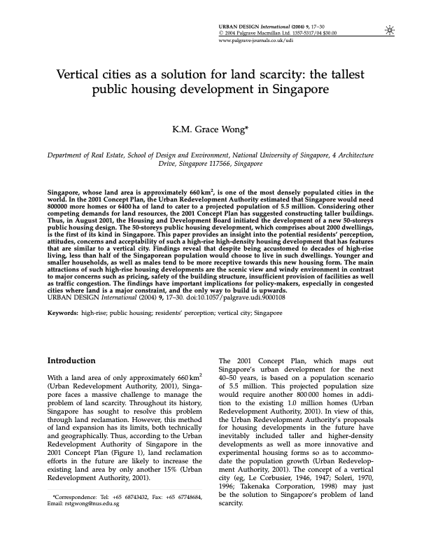
Singapore, whose land area is approximately 660km2, is one of the most densely populated cities in the world. In the 2001 Concept Plan, the Urban Redevelopment Authority estimated that Singapore would need 800000 more homes or 6400 ha of land to cater to a projected population of 5.5 million. Considering other competing demands for land resources, the 2001 Concept Plan has suggested constructing taller buildings. Thus, in August 2001, the Housing and Development Board initiated the development of a new 50-storeys public housing design.
This report focuses on urban poverty and habitat precariousness in the Caribbean countries with an emphasis on current and former British territories.
With urban dwellers purchasing 80 percent or more of their food, understanding urban employment is critical to designing policies and programs to address urban hunger and poverty. Reviewing the literature, but also using data from household surveys conducted by the International Food Policy Research Institute (IFPRI) and others in five countries of Latin America, Asia, and Africa, this paper profiles urban employment in developing-country cities.

Coastal land use and land cover changes, emphasizing the alterations of coastal lagoons, were assessed in northwest Mexico using satellite imagery processing. Supervised classifications of a Landsat series (1973–1997) and the coefficients Kappa (K) and Tau (τ), were used to assess the area and verify the accuracy of the classification of six informational classes (urban area, aquatic systems, mangrove, agriculture, natural vegetation, and aquaculture). Pixel-by-pixel change detection among dates was evaluated using the Kappa Index of Agreement (KIA).

Africa is the fastest urbanizing region in the world, with the population doubling almost every
20 years. The rural population is growing at a rate of 2.5 per cent per annum, while the urban
population is experiencing 5-10 per cent growth per annum. Urbanization becomes a source
of concern when the challenges it poses are far beyond the national management capacity.