Location
African Journal on Land Policy and Geospatial Sciences is a journal specialized in publishing research activities carried out in the field of geo-spatial sciences and land governance. It aims to encourage innovation, promote the exchange of knowledge and scientific outcomes related to its themes. The journal's target community is made-up of researchers, professors and professionals working in the newspaper field. The journal also aims to promote scientific articles and productions at the African, regional and global levels. The institutions as well as the international universities will enrich by their contribution the scientific level of the journal. The journal can, among other things, deal with professional themes and good practices in the field of land governance.
Members:
Resources
Displaying 146 - 150 of 434National Land Coalitions And The Preservation Of Communities’ Ancestral Land Heritage In Africa
National Land Coalitions (NLCs) work towards the recognition, defence, protection and redistribution of land rights at national level. They build upon frameworks on land tenure developed and agreed by different regional and intergovernmental institutions. Platforms are at the heart of protecting and preserving community and customary lands which constitute the major category of landholding in Africa.
Matriarchy At The Crossroads In Africa: The Clash Between Its Theoretical And Practical Orientation In Tanzania’S Land Tenure Systems
Contrary to scholarship that attaches matrilineal practices to women’s control and power over land in Africa. This paper interrogated this theoretical positioning to its contemporary practicality by posing the discussions among the ‘Luguru’ matrilineal of Eastern Tanzania. The article has discussed how land has been claimed, transferred, and owned across gender lens with the apparent changes in political and socio-cultural settings of the community. Shreds of evidence deduced from triangulated approaches provided contradictory conclusions.
Analyse des dynamiques de deux régimes fonciers distincts Cas de la ville de Touba et Ziguinchor (Sénégal)
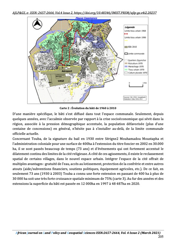
L’originalité de la structure urbaine de Touba réside tout d’abord sur sa gestion dirigée par le Khalif général et son statut particulier d’un titre foncier qui s’adosse sur une forte démographie incontrôlée conjuguée à un fort étalement mal maitrisé. La politique d'urbanisme de Touba semble se résumer à la création de parcelles d'habitation et au libre choix laissé au khalife pour les sites d'implantation d'équipements ou d'infrastructures, et la destination des réserves.
Precipitation And Temperature Trend Analysis By Mann Kendall Test: The Case Of Addis Ababa Methodological Station, Addis Ababa, Ethiopia
The impact of climate change on annual and monthly air precipitation and temperature has received a great deal of attention by scholars worldwide. This study focuses on detecting trends in annual precipitation and temperature for Addis Ababa methodological station located in Addis Ababa. SPSS in combination with the excel spreadsheet used for analyzing the statistics. We were also used the Mann-Kendall trend test and Sen’s slope method to detect trends and the magnitude of change.
The Need For Spatial Data Infrastructure For Sustainable Development In Tanzania
This paper explores the use of spatial data in Tanzania, it underscores the reasons for lagging in the establishment of National Spatial Data Infrastructure. Using documentary analysis, strategically designed interviews, and questionnaires; data were collected from the spatial data user community in Tanzania. Upon simple analysis of the data, the following were the findings: Firstly, it has been revealed that spatial data is not well managed, reused nor shared. Secondly, there are difficulties in the availability and accessibility of spatial data.