Pasar al contenido principal

page search

Displaying 649 - 660 of 1711

DRDLR on its 4th quarter 2015/16 performance; Restitution of Land Rights Amendment Act Constitutional judgement: legal opinion

Legislation & Policies
Agosto, 2016
Sudáfrica

The Department achieved 56% of Q4 targets and 50% of Annual Performance Report targets in its Administration programme while annual targets on vacancies filled and disciplinary cases were partially achieved. In Geospatial and Cadastral Services, the Department achieved 77% of its Q4 targets and 69% of its APR targets. The Rural Development programme achieved 71% of its Q4 targets and 86% of its APR targets. The annual target for establishment of rural information desks was not achieved and the target of jobs created was partially achieved.

Exploring Land Data

Reports & Research
Agosto, 2016
United Kingdom
Global

Quality information on land is crucial to making good decisions about it. Increasing access to this information is important, and it is particularly vital to get it to groups who focus on social and environmental missions. This report is about the information needs of these ‘common good land users’, the data that is available, and how to get it to them. It’s based on a series of interviews with common good land users, data producers, and other experts. We also explored the data, and tested some approaches to making it accessible at a ‘DataDive’ we ran with volunteer data scientists.

Insecure Land Rights in Brazil: Consequences for Rural Areas and Challenges for Improvement

Reports & Research
Julio, 2016
Brazil

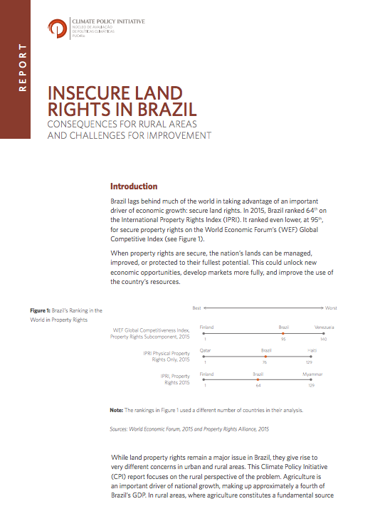
Brazil lags behind much of the world in taking advantage of an important driver of economic growth: secure land rights. In 2015, Brazil ranked 64th on the International Property Rights Index (IPRI). It ranked even lower, at 95th, for secure property rights on the World Economic Forum’s (WEF) Global Competitive Index.


When property rights are secure, the nation’s lands can be managed, improved, or protected to their fullest potential. This could unlock new economic opportunities, develop markets more fully, and improve the use of the country’s resources.

Establishment of a Spatial Data Infrastructure (SDI) for Food and Agriculture

Policy Papers & Briefs
Julio, 2016
Países Bajos

There is no world-wide common platform that stores and provides core data and information related to the assessment, monitoring and mapping of agri-food, environmental and water resources through indicators derived by the combination of remote sensing, geospatial anlysis, in-situ measurement and country reporting. The initiative aims to establish it.

Zambia

Reports & Research
Julio, 2016
Zambia

Zambia’s agriculture sector provides the main support for the rural economy. This assertion is based on the fact that about forty nine percent of the Zambian population depends on agriculture, primarily through smallholder production for their livelihoods and employment (CSO, 2014). Notwithstanding this fact, in 2015 the sector contributed 8.5 percent to the GDP and approximately 9.6 percent of national export earnings (CSO, 2015; World Bank, 2016). The potential for agricultural growth in Zambia is staggering.

FOOD SECURITY AND LAND GOVERNANCE FACTSHEET

Policy Papers & Briefs
Julio, 2016
Uganda

Food security in Uganda relies mainly on access to land and security of tenure. Land governance is marked by the contradiction between relatively progressive legislation and only partial implementation. Institutions that have to deal with land administration and land disputes, such as customary authority systems, local government, and special courts for land justice, have weakened in the last years. Women’s position with respect to land and inheritance also remains weak, both legally and in practice, undermining their livelihoods and status in society.

Integrated geospatial evaluation of manual cadastral mapping: a case study of Pakistan

Peer-reviewed publication
Julio, 2016
Asia
Pakistan

Cadastral mapping in Pakistan is often sketched on paper or cloth and generally falls below cartographic standards, lacking details on coordinate systems, datum and directional information of parcel lines. Survey numbers for parcel identification also lack digital interoperability. Parcel measurements and ownership information are manually recorded in multiple separate registers. The objective of this study is to leverage geospatial technology for automation, auditing and validation of present manual cadastral mapping in Pakistan.

Innovative Land Administration Approaches for Sustainable Development: Belarusian Success Factors

Reports & Research
Julio, 2016
Belarus
Brazil
Central African Republic
Norway
United States of America

Belarus has preserved its third position in Registering Property in the World Bank’s Doing Business 2014 report. Constant improvement of property registration procedures has allowed Belarus to achieve that. The Registering Property indicator takes into account three factors: the number of procedures required to transfer rights to property, the time spent on completing all the necessary procedures and the cost of procedures. From ”The Earth Summit“ in Brazil 1992 sustainable development recognized by almost all societies as one of the major global goals.

Social exclusion and land administration in Orissa, India

Reports & Research
Julio, 2016
India
British Indian Ocean Territory

The authors report on the first empirical study of its kind to examine - from the perspective of transaction costs - factors that constrain access to land for the rural poor and other socially excluded groups in India. They find that: a) Land reform has reduced large landholdings since the 1950s. Medium size farms have gained most. Formidable obstacles still prevent the poor from gaining access to land. b) The complexity of land revenue administration in Orissa is partly the legacy of distinctly different systems, which produced more or less complete and accurate land records.

Using Administrative Data to Assess the Impact and Sustainability of Rwanda's Land Tenure Regularization

Julio, 2016

Rwanda's completion, in 2012/13, of
a land tenure regularization program covering the entire
country allows the use of administrative data to describe
initial performance and combine the data with household
surveys to quantify to what extent and why subsequent
transfers remain informal, and how to address this. In
2014/15, annual volumes of registered sales ranged between
5.6 percent for residential land in Kigali and 0.1 percent

Our Customary Lands - Community-Based Sustainable Natural Resource Management in Burma

Policy Papers & Briefs
Julio, 2016
Myanmar

Executive summary:
"In January 2016 the government adopted a National Land Use Policy, which included the recognition
of customary land management practices. While this is a welcome first step in the necessary
integration of Burma’s customary land management systems with the national-level system,
there is an urgent need for constitutional reform and devolution of land management powers
prior to any such integration.
This report by the Ethnic Community Development Forum (ECDF) presents how Burma’s diverse