Passar para o conteúdo principal

page search

Issuesuso da terraLandLibrary Resource
There are 9, 839 content items of different types and languages related to uso da terra on the Land Portal.

uso da terra

AGROVOC URI:

Displaying 4225 - 4236 of 4573

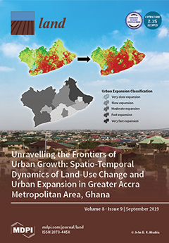
Unravelling the Frontiers of Urban Growth: Spatio-Temporal Dynamics of Land-Use Change and Urban Expansion in Greater Accra Metropolitan Area, Ghana

Peer-reviewed publication
Setembro, 2019
Gana

This study analyzed and assessed spatio-temporal dynamics of land-use change (LUC) and urban expansion (UE) within the Greater Accra Metropolitan Area (GAMA) of Ghana. This region serves as a case to illustrate how a major economic hub and political core area is experiencing massive spatial transformations, resulting in uneven geographies of urban land expansion. Quickbird/Worldview-2 images for the years 2008 and 2017 were segmented and classified to produce LUC maps. LUC and UE were analyzed by post-classification change detection and spatial metrics, respectively.

Flooding and Land Use Change in Southeast Sulawesi, Indonesia

Peer-reviewed publication
Setembro, 2019
Indonésia
Sudeste Asiático

Flooding is a routine occurrence throughout much of the monsoonal tropics. Despite well-developed repertoires of response, agrarian societies have been ‘double exposed’ to intensifying climate change and agro-industrialization over the past several decades, often in ways that alter both the regularity of flood events and individual and community capacity for response.

Dynamics of Land Use and Land Cover Changes in Harare, Zimbabwe: A Case Study on the Linkage between Drivers and the Axis of Urban Expansion

Peer-reviewed publication
Outubro, 2019
Zimbabwe

With increasing population growth, the Harare Metropolitan Province has experienced accelerated land use and land cover (LULC) changes, influencing the city’s growth. This study aims to assess spatiotemporal urban LULC changes, the axis, and patterns of growth as well as drivers influencing urban growth over the past three decades in the Harare Metropolitan Province. The analysis was based on remotely sensed Landsat Thematic Mapper and Operational Land Imager data from 1984–2018, GIS application, and binary logistic regression.

Challenges for Monitoring the Extent and Land Use/Cover Changes in Monarch Butterflies’ Migratory Habitat across the United States and Mexico

Peer-reviewed publication
Outubro, 2019
México
Estados Unidos

This paper presents a synopsis of the challenges and limitations presented by existing and emerging land use/land cover (LULC) digital data sets when used to analyze the extent, habitat quality, and LULC changes of the monarch (Danaus plexippus) migratory habitat across the United States of America (US) and Mexico. First, the characteristics, state of the knowledge, and issues related to this habitat are presented.

Valuing Environmental Amenities across Space: A Geographically Weighted Regression of Housing Preferences in Greenville County, SC

Peer-reviewed publication
Outubro, 2019
Global

As global consumption and development rates continue to grow, there will be persistent stress placed on public goods, namely environmental amenities. Urban sprawl and development places pressure on forested areas, as they are often displaced or degraded in the name of economic development. This is problematic because environmental amenities are valued by the public, but traditional market analysis typically obscures the value of these goods and services that are not explicitly traded in a market setting.

Evolution and Collapse of Ejidos in Mexico—To What Extent Is Communal Land Used for Urban Development?

Peer-reviewed publication
Outubro, 2019
México
Alemanha

The ejido system, based on communal land in Mexico, was transformed to private ownership due to neoliberal trends in the 1990s. Based on the theory of stakeholders being agents of change, this study aimed to describe the land policies that changed the ejido system into private development to show how land tenure change is shaping urban growth. To demonstrate this, municipalities of San Andrés Cholula and Santa Clara Ocoyucan were selected as case studies.

Regional Differentiation of Long-Term Land Use Changes: A Case Study of Czechia

Peer-reviewed publication
Novembro, 2019
República Checa

The major topic of this article is the evaluation of the regional differentiation of the long-term changes in land use in Czechia. This study searches the spatial and temporal differentiation of the changes and their driving forces since the 19th century. The comprehensive land use land cover change database (LUCC Czechia Database) which comprises cadastral data on the land use in the years 1845, 1896, 1948, 1990, 2000, and 2010 for more than 8000 units, was the main data source.

Urban–Rural Construction Land Replacement for More Sustainable Land Use and Regional Development in China: Policies and Practices

Peer-reviewed publication
Novembro, 2019
China

With the rapid development of urbanization and industrialization, land exploitation in China has caused a decrease of cultivated land, posing a threat to national food security. To achieve the goals of both economic development and cultivated land protection, China launched an urban–rural land replacement measure supported by a new land use policy of “increasing vs. decreasing balance” of construction land between urban and rural areas in 2008.

Influence of Landscape Pattern Changes on Runoff and Sediment in the Dali River Watershed on the Loess Plateau of China

Peer-reviewed publication
Dezembro, 2019
China

The large-scale Grain for Green project on the Loess Plateau of China significantly changes the regional landscape pattern, which has a profound impact on runoff and sediment process. The relationship between landscape pattern and runoff and sediment in the Dali River watershed is established. Cropland and grassland areas in the watershed show a downward trend, whereas the woodland and building land increases continuously. The Number of Patches (NP), Patch Density (PD) and Landscape Diversity (SHDI), Landscape Division Index (DIVISION) increase significantly.

Land and water management in Kenya: towards sustainable land use.

Reports & Research
Dezembro, 2000
Quênia

Preliminary findings on the effects of land use in the Masinga Dam catchment, Kenya, on the storage capacity of the reservoir are presented. Remote sensing and GIS techniques, supplemented with ground reports, were used to determine areas most susceptible to erosion. A representative catchment was then chosen for rainy season monitoring of soil loss, river suspended sediments and discharge response to rainfall. In addition, Gerlach-type traps were used to evaluate erosion rates under different crop covers and slope gradients.

Civil Society Position on The Draft National Land Policy

Policy Papers & Briefs
Março, 2007
Quênia

The Civil Society commends the Ministry of Lands for spearheading the important process of developing the Draft National Policy, and affirms that land is central to the livelihoods of most Kenyans and as such its access, use, ownership, administration and distribution are of key national concern. Thus, having critically examined the Draft Policy we do hereby make our position on the way forward on the salient policy proposals of the Draft National Land Policy document.

Irregular and illegal Land Acquisition by Kenya’s Elites: Trends, Processes, and Impacts of Kenya’s Land-Grabbing Phenomenon

Journal Articles & Books
Janeiro, 2011
Quênia

The International Land Coalition (ILC) has commissioned this present report to analyze the illegal/irregular acquisition of land by Kenya’s elites to ascertain the types of land affected, the processes used to acquire land, and the profiles of the perpetrators, as well as to identify the victims and the impacts of land grabbing. The report is drawn largely from the Kenya Land Alliance (KLA)’s series “Unjust Enrichment: The Making of Land Grabbing Millionaires”,