Passar para o conteúdo principal

page search

Displaying 289 - 300 of 8599

Not seeing the carbon for the trees? Why area-based targets for establishing new woodlands can limit or underplay their climate change mitigation benefits

Peer-reviewed publication
Agosto, 2020
United States of America

Area-based targets for afforestation are a frequent and prominent component of policy discourses on forestry, land use and climate change emissions abatement. Such targets imply an expected contribution of afforestation to the net reduction of greenhouse gas emissions, yet the nature of afforestation undertaken and its geographical distribution means that there is considerable uncertainty over the eventual emission reductions outcomes.

Gobernanza de la Tierra y los Objetivos de Desarrollo Sustentable en Argentina

Policy Papers & Briefs
Agosto, 2020
Argentina

El presente informe fue construido de manera conjunta por las Iniciativas “ODS y Tierra”, “ENI Argentina” y “Land Matrix”. Su objetivo es realizar contribuciones al Estado y a la sociedad en general, para mejorar la implementación de los ODS y sus Metas relacionadas a la Tierra en la República Argentina. Para tal fin, se utilizaron datos extraídos del documento “Trayectoria de las Metas de Tierra de los ODS en Argentina”, estudio encargado por la ENI Argentina a la consultora Dra.

Determination of Farmers’ Willingness to Pay for Sustainable Agricultural Land Use in the GAP-Harran Plain of Turkey

Peer-reviewed publication
Agosto, 2020
Turkey

There is a risk of salinity and degradation in soil structure due to excessive irrigation in the GAP-Harran Plain. The purpose of the research is to determine farmers’ willingness to pay (WTP) for applications of sustainable agricultural land usage practices to avoid salinization in soil based on irrigation problems related to the demands of the farmers’, their needs, and which factors affect their willingness to accept payment. The basic material of the research was obtained through face-to-face questionnaires from farmers who were selected by a method of simple random sampling in 2018.

30 Years of Land Cover Change in Connecticut, USA: A Case Study of Long-Term Research, Dissemination of Results, and Their Use in Land Use Planning and Natural Resource Conservation

Peer-reviewed publication
Agosto, 2020
Norway
United States of America

Remotely sensed land cover data can be a tremendous resource to land use decision makers, yet there is often a disconnect between the worlds of remote sensing and local government. The Connecticut’s Changing Landscape project is focused on bridging this gap. The project analyzes changes to the state’s landscape using Landsat-derived 30-m land cover and cross-correlation analysis. It includes seven dates spanning 30 years, from 1985 to 2015.

A Conceptual Framework to Design Green Infrastructure: Ecosystem Services as an Opportunity for Creating Shared Value in Ground Photovoltaic Systems

Peer-reviewed publication
Agosto, 2020
Italy
Portugal
United States of America

This paper presents a conceptual framework that looks at photovoltaic systems in synergy with ecosystem services. The focus is to connect business success with social and ecological progress based on the operative concept of multifunctional land use. Such an approach attempts to harmonise the needs of the industrial processes of photovoltaic systems and the ecological and social needs of the landscape context. Different from the usual design of ground photovoltaic systems in farmlands or brownfields, a new framework is proposed, combining photovoltaic panels and vegetation.

Spatially Explicit Reconstruction of Anthropogenic Grassland Cover Change in China from 1700 to 2000

Peer-reviewed publication
Agosto, 2020
China

Long-term anthropogenic land use and land cover changes (LULCCs) are regarded as an important component of past global change. The past 300 years have witnessed dramatic changes in LULCC in China, and this has resulted in the large-scale conversion of natural vegetation to agricultural landscapes. Studies of past LULCC in China have mainly focused on cropland and forest; however, estimates of grassland cover remain rare due to the scarcity of grassland-related historical documents.

Infiltration-Friendly Agroforestry Land Uses on Volcanic Slopes in the Rejoso Watershed, East Java, Indonesia

Peer-reviewed publication
Agosto, 2020
Australia
Belgium
Canada
Indonesia
United States of America

Forest conversion to agriculture can induce the loss of hydrologic functions linked to infiltration. Infiltration-friendly agroforestry land uses minimize this loss. Our assessment of forest-derived land uses in the Rejoso Watershed on the slopes of the Bromo volcano in East Java (Indonesia) focused on two zones, upstream (above 800 m a.s.l.; Andisols) and midstream (400–800 m a.s.l.; Inceptisols) of the Rejoso River, feeding aquifers that support lowland rice areas and drinking water supply to nearby cities.

Impact of cropland displacement on the potential crop production in China: a multi-scale analysis

Journal Articles & Books
Agosto, 2020

Changes in the amount and location of cropland areas may affect the potential crop production at different spatial scales. However, most studies ignore the impacts of cropland displacement on potential crop production. In many countries, cropland protection policies mainly aim for no loss in cropland area, while there is no restriction on change of cropland location. Taking China as the study area, we analyze the impacts of cropland displacement on potential crop production at four administrative levels during the period 2000 and 2018.

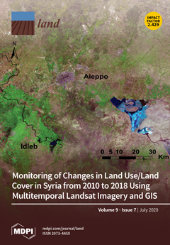
Monitoring of Changes in Land Use/Land Cover in Syria from 2010 to 2018 Using Multitemporal Landsat Imagery and GIS

Peer-reviewed publication
Julho, 2020
Syrian Arab Republic

Understanding the effects of socio-ecological shocks on land use/land cover (LULC) change is essential for developing land management strategies and for reducing adverse environmental pressures. Our study examines the impacts of the armed conflict in Syria, which began in mid-2011, and the related social and economic crisis on LULC between 2010 and 2018. We used remote sensing for change detection by applying a supervised maximum likelihood classification to Landsat images of the three target years 2010, 2014, and 2018.

Five scale challenges in Ecuadorian forest and landscape restoration governance

Peer-reviewed publication
Junho, 2020
Alemanha
Equador

The forest and landscape restoration (FLR) targets set as part of the Bonn Challenge draw attention to the governance arrangements required to translate national FLR targets into local action. To achieve the targets, actors at multiple levels of the governance scale aim to influence relevant processes on the ecological scale. In this article, we focus on the scale challenges relating to the implementation of Ecuador’s restoration targets, by analysing the implementation of the 2014–2017 National Forest Restoration Plan in the montane Chocó Andino and Bosque Seco landscapes.

The significance of different realms of value for agricultural land in Sweden

Peer-reviewed publication
Junho, 2020
Suécia

The demand for additional agricultural land is expected to rise by approximately 50 per cent by 2050 on a global level, and agricultural land of high quality needs to be preserved to ensure future food security. However, agricultural land per capita is decreasing. One of the main reasons for this in the EU and globally is the building of houses or infrastructure on agricultural land. There is a possibility that the Swedish agricultural sector will grow in the future and supply more regions than its own territory with food due to, e.g., climate change.