
The delineation and protection of transhumance corridors are increasingly seen as critical to maintaining livestock mobility in agropastoral areas of West Africa by allowing passage through areas of increasing cropping pressure. Understanding the local politics surrounding the mapping and…
The only well-studied wintering ground of the globally threatened Aquatic Warbler Acrocephalus paludicola is the ‘Djoudj area’ in Senegal. This study identifies potential Aquatic Warbler habitats within that area and gives an estimate of the size of the local wintering population. A land-cover…
Local vegetation trends in the Sahel of Mali and Senegal from Geoland Version 1 (GEOV1) (5 km) and the third generation Global Inventory Modeling and Mapping Studies (GIMMS3g) (8 km) Fraction of Absorbed Photosynthetically Active Radiation (FAPAR) time series are studied over 29 years. For…

En este libro se cuenta el relato de estas siete décadas de historia de la FAO, de sus protagonistas y de sus hechos. Se han rescatado del archivo de la FAO imágenes inéditas en blanco y negro de los primeros años de la Organización que configuran un portfolio de intensas y hermosas imágenes. El…
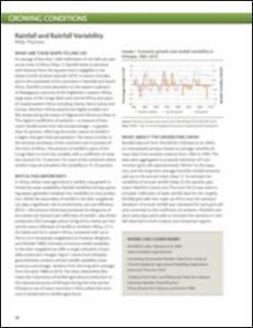
In Africa, where most agriculture is rainfed, crop growth is limited by water availability. Rainfall variability during a growing season generally translates into variability in crop production. While the seasonality of rainfall in the drier rangelands can play a significant role in productivity…
The present report gives the complete description of the preparation of a land use map and also the preparation of a national map of livestock intensity, needed as LUS input. The present method allows the preparation of a multi-country land use map in two weeks with the work of 13 experts, and…
Meeting symbol/code: GSPPA-II/14/ Report
Session: Sess.2
Cette troisième réunion du groupe de travail Biodiversité, Habitat et Qualité de l’Eau a été ouverte conjointement par M. Birane Sambe, coordinateur régional du projet CCLME et M. Abou Bamba, secrétaire de la Convention d’Abidjan. M. Sambe a remercié l’ensemble des participants d’avoir effectué…
The present report gives the complete description of the preparation of a land use map and also the preparation of a national map of livestock intensity, needed as LUS input. The present method allows the preparation of a multi-country land use map in two weeks with the work of 13 experts, and…