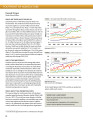
Maize yield potential
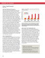
Peer-reviewed publication
Dezembro, 2014
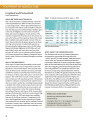
África Oriental
África Ocidental
África austral
África subsariana
África
AGROVOC URI:
Desarrollo Rural y TIC
Mariana Fossetti*
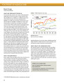
Sailing out to sea in the morning and returning without a catch in the evening is now a thing of the past for many Indian fishermen. A satellite-based information system shows where they can find rich fishing grounds.
Global demand for timber, agricultural commodities, and extractives is a significant driver of deforestation worldwide. Transparent land-concessions data for these large-scale commercial activities are essential to understand drivers of forest loss, monitor environmental impacts of ongoing activities, and ensure efficient and sustainable allocation of land.

A landscape epidemiology modeling framework is presented which integrates the simulation outputs from an established spatial agent-based model (ABM) of malaria with a geographic information system (GIS). For a study area in Kenya, five landscape scenarios are constructed with varying coverage levels of two mosquito-control interventions. For each scenario, maps are presented to show the average distributions of three output indices obtained from the results of 750 simulation runs. Hot spot analysis is performed to detect statistically significant hot spots and cold spots.