Passar para o conteúdo principal

page search

There are 1, 105 content items of different types and languages related to sistema de informação geográfica on the Land Portal.
Displaying 157 - 168 of 361

Detection of Urban Development in Uyo (Nigeria) Using Remote Sensing

Peer-reviewed publication
Junho, 2019
Nigéria

Uyo is one of the fastest-growing cities in Nigeria. In recent years, there has been a widespread change in land use, yet to date, there is no thorough mapping of vegetation change across the area. This study focuses on land use change, urban development, and the driving forces behind natural vegetation loss in Uyo.

Multi-Criteria Decision Analysis for the Land Evaluation of Potential Agricultural Land Use Types in a Hilly Area of Central Vietnam

Peer-reviewed publication
Junho, 2019
Global

Land evaluation is a process that is aimed at the sustainable development of agricultural production in rural areas, especially in developing countries. Therefore, land evaluation involves many aspects of natural conditions, economic, and social issues. This research was conducted in a hilly region of Central Vietnam to assess the land suitability of potential agricultural land use types that are based on scientific and local knowledge.

Land-Use and Land-Cover (LULC) Change Detection in Wami River Basin, Tanzania

Peer-reviewed publication
Setembro, 2019
Tanzania

Anthropogenic activities have substantially changed natural landscapes, especially in regions which are extremely affected by population growth and climate change such as East African countries. Understanding the patterns of land-use and land-cover (LULC) change is important for efficient environmental management, including effective water management practice. Using remote sensing techniques and geographic information systems (GIS), this study focused on changes in LULC patterns of the upstream and downstream Wami River Basin over 16 years.

Using Farmer Decision Rules for Mapping Historical Land Use Change Patterns from 1954 to 2007 in Rural Northwestern Vietnam

Peer-reviewed publication
Setembro, 2019
Vietnam

The present study revealed how local socioecological knowledge elucidated during participatory rural appraisals and historical remote sensing data can be combined for analyzing land use change patterns from 1954 to 2007 in northwestern Vietnam. The developed approach integrated farmer decision rules on cropping preferences and location, visual and supervised classification methods, and qualitative information obtained during various forms of participatory appraisals.

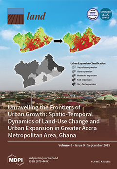
Unravelling the Frontiers of Urban Growth: Spatio-Temporal Dynamics of Land-Use Change and Urban Expansion in Greater Accra Metropolitan Area, Ghana

Peer-reviewed publication
Setembro, 2019
Gana

This study analyzed and assessed spatio-temporal dynamics of land-use change (LUC) and urban expansion (UE) within the Greater Accra Metropolitan Area (GAMA) of Ghana. This region serves as a case to illustrate how a major economic hub and political core area is experiencing massive spatial transformations, resulting in uneven geographies of urban land expansion. Quickbird/Worldview-2 images for the years 2008 and 2017 were segmented and classified to produce LUC maps. LUC and UE were analyzed by post-classification change detection and spatial metrics, respectively.

How Much is Enough? Improving Participatory Mapping Using Area Rarefaction Curves

Peer-reviewed publication
Novembro, 2019
Filipinas

Participatory mapping is a valuable approach for documenting the influence of human activities on species, ecosystems, and ecosystem services, as well as the variability of human activities over space and time. This method is particularly valuable in data-poor systems; however, there has never been a systematic approach for identifying the total number of respondents necessary to map the entire spatial extent of a particular human activity. Here, we develop a new technique for identifying sufficient respondent sample sizes for participatory mapping by adapting species rarefaction curves.

Modelling Land Cover Changes in Peri-Urban Areas: A Case Study of George Town Conurbation, Malaysia

Peer-reviewed publication
Setembro, 2020
Ásia Oriental
Malásia

Drastic growth of urban populations has caused expansion of peri-urban areas—the transitional zone between a city and its hinterland. Although urbanisation may bring economic opportunities and improve infrastructure in an area, uncontrolled urban expansion towards peri-urban areas will negatively impact the environment and the community living within the area. Malaysia, for example, has become one of the most urbanised countries in East Asia. However, cities in Malaysia are relatively small and less densely populated compared with other cities in East Asia.

Mapping Flood-Based Farming Systems with Bayesian Networks

Peer-reviewed publication
Setembro, 2020
Etiópia
Quênia

Many actors in agricultural research, development, and policy arenas require accurate information on the spatial extents of cropping and farming practices. While remote sensing provides ways for obtaining such information, it is often difficult to distinguish between different types of agricultural practices or identify particular farming systems. Stochastic system behavior or similarity in the spectral signatures of different system components can lead to misclassification.

End of Desertification? Disputing Environmental Change in the Drylands

Journal Articles & Books
Dezembro, 2016
Argentina
Burkina Faso
República Centro-Africana
China
Camarões
Argélia
Eritreia
Etiópia
Mali
Mauritânia
Níger
Nigéria
Sudão
Senegal
Sudão do Sul
Chade
Ásia Central

It took scientists more than three decades to transform a perceived desertification crisis in the Sahel into a non-event. Looking beyond the Sahel, the chapters in this book provide case studies from around the world that examine the use and relevance of the desertification concept.

Identifying hotspots in land use land cover change and the drivers in a semi-arid region of India

Journal Articles & Books
Dezembro, 2018
Índia

The study examines long-term land use/land cover change (LUCC) at a finer scale in a semi-arid region of India. The objectives were to study and quantify the spatiotemporal LUCC and uncover the major drivers causing the change in the Mula Pravara river basin, which is located in a semi-arid region of Maharashtra state, India.

Cadastral Data Model for an Informal Settlement: Case Study of Huruma, Nairobi – Kenya

Peer-reviewed publication
Abril, 2019
Quênia

The complexity of tenure claims in the informal settlements has been difficult to incorporate into the formal systems owing to their dynamic and continuously changing nature. Innovative tools are therefore required to capture these claims. This requires the development of a cadastral data model specifically for informal settlements that would document such claims to make it easier to manage the current situation as well as prepare for future formalization processes such as regularization or relocation.