The Land Portal, Global Data Barometer, and Open Data Charter are working together at the nexus of open data and land governance. This blog shares how we are bringing our complementary expertise and passions for more open and transparent land data systems.
The problem
Right now, we lack a baseline understanding of the extent to which various land information is available, accessible, and open across the world. Case studies of open land information use are scarce. Governments and other stakeholders do not use a common global framework for deciding which land-related datasets to create or make open, or how to integrate these with other datasets, though there are now several initiatives trying to fill this gap. Different stakeholder groups including private sector, legal community, governments, technology community and geospatial specialists often have parallel conversations about their data needs. Increasing access to land-related data is a key part of building an information ecosystem for land governance. Effective use of open land data can support better informed decision and policy making, help secure land rights for the most marginalised, and support the fight against land-related corruption.
Global partnership approach
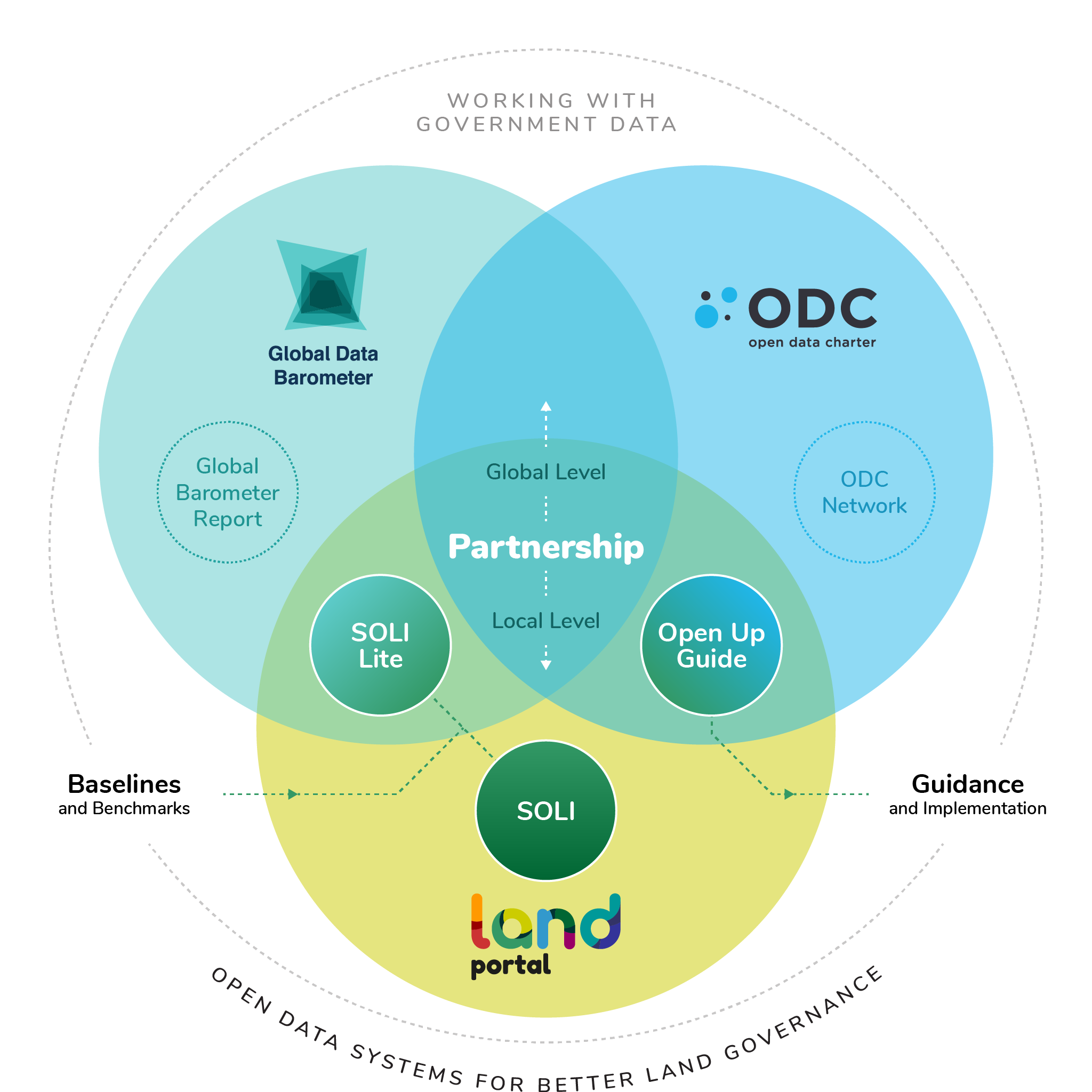
Over the last two years the Land Portal Foundation has collaborated with Global Data Barometer and Open Data Charter to embed land issues within key open data activities. Our partnership aims to deliver tools needed to understand and strengthen national land information ecosystems, and ultimately enable a more open state wherein accessible information and responsible re-use of data can create positive change.
In 2019 the Land Portal developed a methodology to assess country level land information ecosystems, assessing the availability and accessibility of data on: Land tenure; Land cover, use and management; Land disputes; Human settlements; Land markets and financing; and Land, climate change and environment. This method has been applied to develop in-depth State of Open Land Information (SOLI) reports on Kenya, Uganda, South Sudan and Tanzania and South Africa thus far.
In parallel, Land Portal has been engaging with the development of the Global Data Barometer, a new benchmark supported by the International Development Research Centre , the United Nations Population Fund, and numerous regional and thematic partners such as the Open Government Partnership, Transparency International, among others (building on the Open Data Barometer), which will provide insight into government data capability, data availability, and data use, across 100+ countries.
A land module within the Global Data Barometer will provide a baseline on the state of open land information worldwide, drawing on a network of 100+ country expert researchers to identify regional leaders and laggards in making land data available, and assessing the extent to which countries have the frameworks in place for responsible re-use of data. The Global Data Barometer’s survey will also surface potential case studies of land data re-use, and will provide insights to target future in-depth SOLI reports.
These two projects -- the land module and the SOLI reports -- will be mutually reinforcing, with the global study highlighting the comparative position of different countries, and supporting research into contextual best-fit strategies to open up land information in different countries and regions. The national SOLI process supports multi-stakeholder action to improve land information ecosystems.
To support the development of country level strategies to open up land information Land Portal and the Open Data Charter have worked together to develop an Open Up Guide for Land Governance. It is a practical guide to help governments collect and release land-related data for improved citizen engagement, decision-making, and innovation. The Open Up Guide on Land Governance is a tool to enable stakeholders to develop a clear roadmap.
The Open Up Guide on Land Governance is built upon a consolidated research methodology of the Open Data Charter. Open Data Charter’s Open Up Guides provide a model for stakeholders to come together and agree on:
-
Key thematic datasets and standards
-
Level of openness of these key datasets
-
Key use cases for open data in a particular domain
-
A common framework to collaboratively prioritize datasets
Existing Open Up Guides on agriculture, anti-corruption and the environment have been used to support regional collaboration, and to secure government commitments to greater availability and usability of data. An Open Up Guide is not just another toolkit or handbook - but instead is the result of a process of stakeholder engagement to find the alignment between different data needs, and to provide a framework that can support country-level advocacy and action planning.
How it fits together: