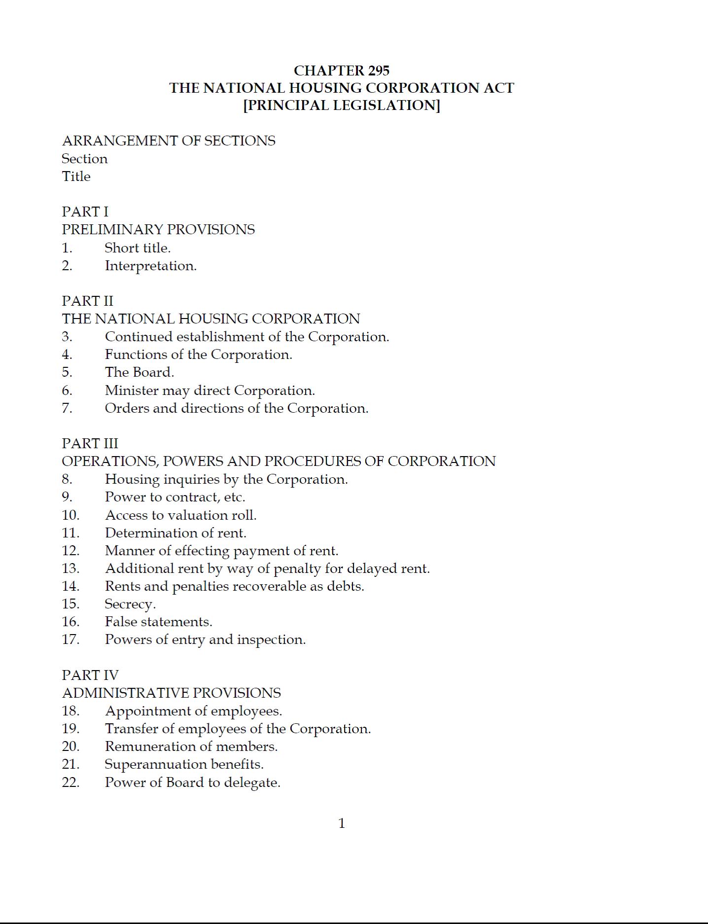
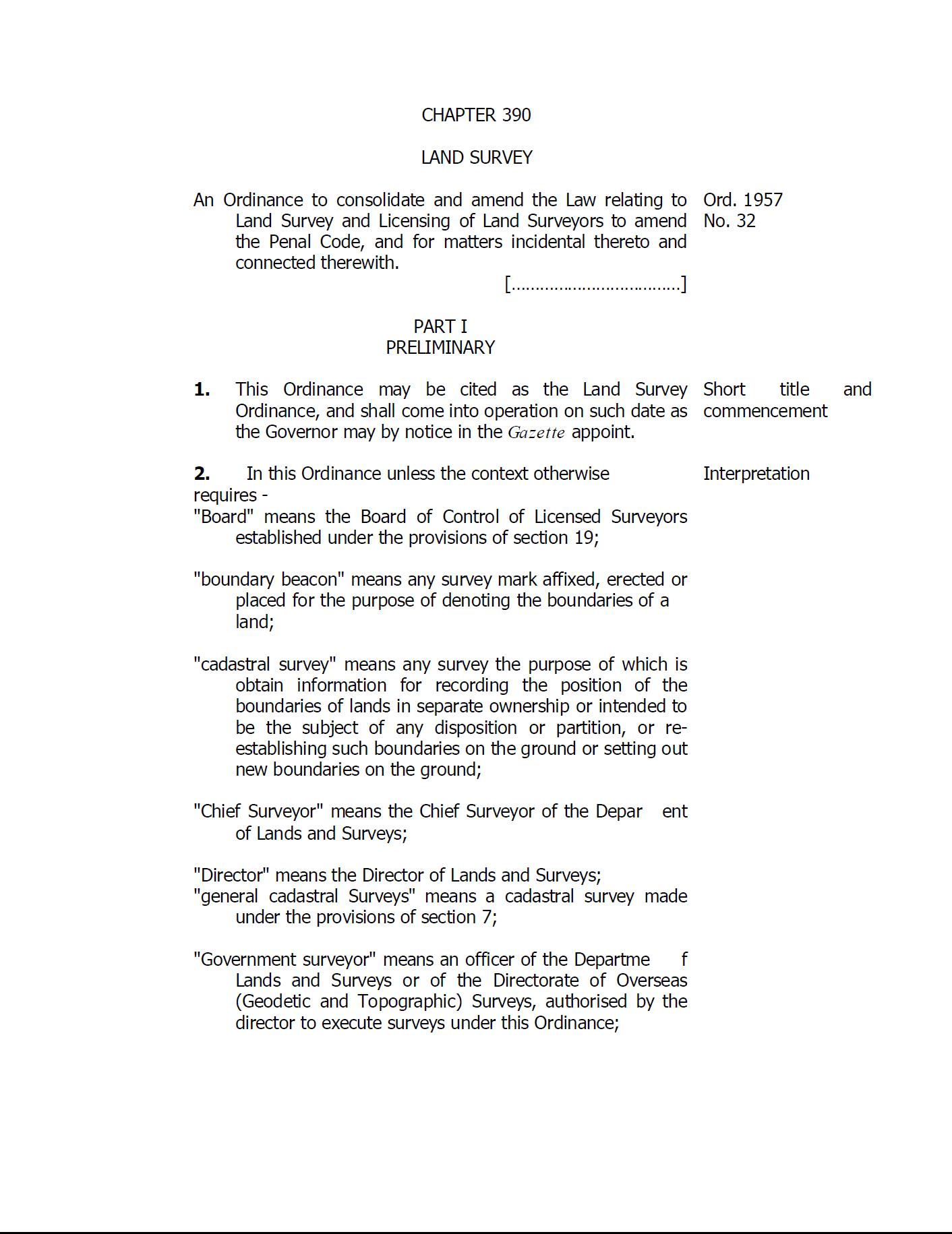
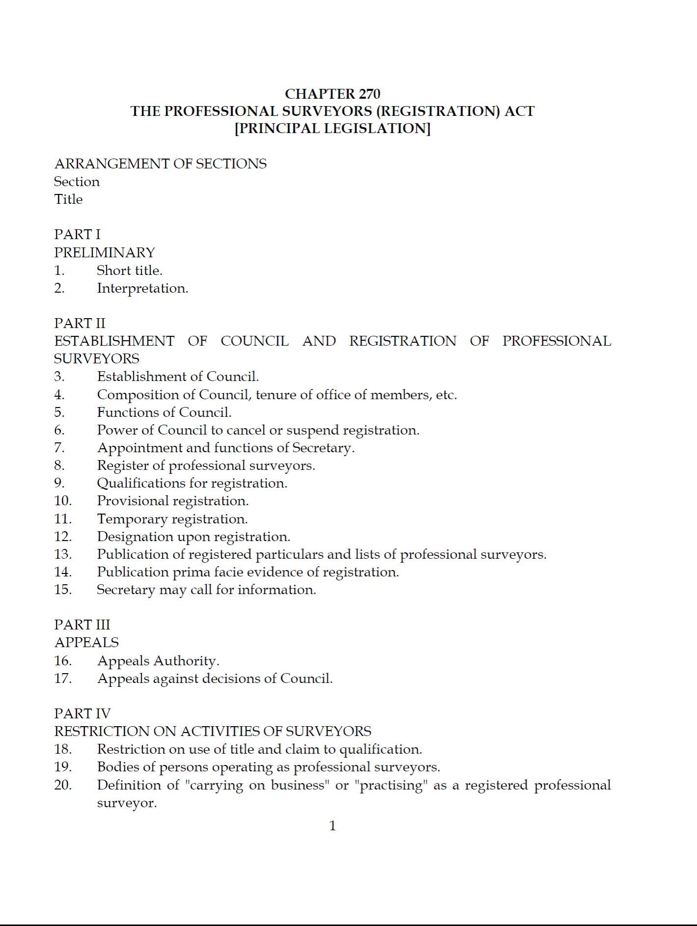
Pasar al contenido principal

page search

IssuesUrbanizaciónLandLibrary Resource
There are 1, 888 content items of different types and languages related to Urbanización on the Land Portal.

Urbanización

AGROVOC URI:

Displaying 97 - 108 of 699

Land Survey Ordinance

Legislation
Noviembre, 1957
Tanzania

An Ordinance to consolidate and amend the Law relating to Land Survey and Licensing of Land Surveyors to amend the Penal Code, and for matters incidental thereto and connected therewith. 

New Cropland on Former Rangeland and Lost Cropland from Urban Development: The “Replacement Land” Debate

Peer-reviewed publication
Septiembre, 2014

In this study, a land use/land cover change analysis method was developed to examine patterns of land use/land cover conversions of cropland to urban uses and conversions of rangeland to cropland uses in the United States (US) Midwest region. We used the US 2001 and 2006 National Land Cover Datasets (NLCD) for our spatial analyses of these conversion trends.

Human Appropriation of Net Primary Production (HANPP) in an Agriculturally-Dominated Watershed, Southeastern USA

Peer-reviewed publication
Junio, 2015

Human appropriation of net primary production (HANPP) quantifies alteration of the biosphere caused by land use change and biomass harvest. In global and regional scale assessments, the majority of HANPP is associated with agricultural biomass harvest. We adapted these methods to the watershed scale and calculated land cover change and HANPP in an agricultural watershed in 1968 and 2011. Between 1968 and 2011, forest cover remained near 50% of the watershed, but row crop decreased from 26% to 0.4%, pasture increased from 19% to 32%, and residential area increased from 2% to 10%.

“Nothing Is Like It Was Before”: The Dynamics between Land-Use and Land-Cover, and Livelihood Strategies in the Northern Vietnam Borderlands

Peer-reviewed publication
Diciembre, 2015

Land uses are changing rapidly in Vietnam’s upland northern borderlands. Regional development platforms such as the Greater Mekong Subregion, state-propelled market integration and reforestation programs, and lowland entrepreneurs and migrants are all impacting this frontier landscape. Drawing on a mixed methods approach using remote sensing data from 2000 to 2009 and ethnographic fieldwork, we examine how land-use and land-cover change (LULCC) has occurred across three borderland provinces—Lai Châu, Lào Cai and Hà Giang—with high proportions of ethnic minority semi-subsistence farmers.

Modeling Future Urban Sprawl and Landscape Change in the Laguna de Bay Area, Philippines

Peer-reviewed publication
Junio, 2017

This study uses a spatially-explicit land-use/land-cover (LULC) modeling approach to model and map the future (2016–2030) LULC of the area surrounding the Laguna de Bay of Philippines under three different scenarios: ‘business-as-usual’, ‘compact development’, and ‘high sprawl’ scenarios. The Laguna de Bay is the largest lake in the Philippines and an important natural resource for the population in/around Metro Manila.

Agricultural Land Fragmentation at Urban Fringes: An Application of Urban-To-Rural Gradient Analysis in Adelaide

Peer-reviewed publication
Junio, 2017

One of the major consequences of expansive urban growth is the degradation and loss of productive agricultural land and agroecosystem functions. Four landscape metrics—Percentage of Land (PLAND), Mean Parcel Size (MPS), Parcel Density (PD), and Modified Simpson’s Diversity Index (MSDI)—were calculated for 1 km × 1 km cells along three 50 km-long transects that extend out from the Adelaide CBD, in order to analyze variations in landscape structures. Each transect has different land uses beyond the built-up area, and they differ in topography, soils, and rates of urban expansion.

Spatial and Temporal Characteristics of Road Networks and Urban Expansion

Peer-reviewed publication
Junio, 2017

Urban expansion has become a widespread trend in developing countries. Road networks are an extremely important factor driving the expansion of urban land and require further study. To investigate the relationship between road networks and urban expansion, we selected Beijing, New York, London, and Chicago as study areas. First, we obtained urban land use vector data through image interpretation using a remote sensing (RS) and geographic information systems (GIS) platform and then used overlay analysis to extract information on urban expansion.

Development of Future Land Cover Change Scenarios in the Metropolitan Fringe, Oregon, U.S., with Stakeholder Involvement

Peer-reviewed publication
Marzo, 2014

We describe a future land cover scenario construction process developed under consultation with a group of stakeholders from our study area. We developed a simple geographic information system (GIS) method to modify a land cover dataset and then used qualitative data extracted from the stakeholder storyline to modify it. These identified variables related to our study area’s land use regulation system as the major driver in the placement of new urban growth on the landscape; and the accommodation of new population as the determinant of its growth rate.

Spatiotemporal Patterns and Socioeconomic Contexts of Vegetative Cover in Altamira City, Brazil

Peer-reviewed publication
Diciembre, 2013
Brasil

Ecosystem services provided by urban vegetation can ameliorate problems common to urban environments while improving the quality of life of urban residents. Much research in urban ecology has analyzed urban environmental dynamics in the global north; rapidly urbanizing areas in the global south have not received commensurate attention. The land cover dynamics of mid-sized cities in the global south remain under-explored in particular.