Aller au contenu principal

page search

Issuesadministration foncièreLandLibrary Resource
There are 3, 541 content items of different types and languages related to administration foncière on the Land Portal.
Displaying 409 - 420 of 739

The GeoCitizen-approach: community-based spatial planning – an Ecuadorian case study

Journal Articles & Books
Mars, 2014
Équateur
Amérique centrale
Amérique du Sud

Over the last years, geospatial web platforms, social media, and volunteered geographic information (VGI) have opened a window of opportunity for traditional Public Participatory GIS (PPGIS) to usher in a new era. Taking advantage of these technological achievements, this paper presents a new approach for a citizen-orientated framework of spatial planning that aims at integrating participatory community work into existing decision-making structures.

Towards wellbeing in forest communities: a source book for local government

Journal Articles & Books
Décembre, 2007
Bolivie
Indonésie

Governments in many countries are decentralising to give more control over decision making and budgets to local administrations. One expectation of this change is that local governments will more effectively and efficiently respond to the poorest citizens in their jurisdictions. Decentralisation is especially significant to forest communities, which have historically benefited little from government services and poverty reduction programmes because of their physical isolation and social marginalisation.

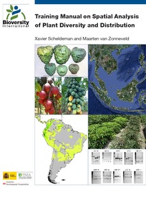
Training manual on spatial analysis of plant diversity and distribution

Training Resources & Tools
Décembre, 2010

This training manual is intended for scientists and students who work with biodiversity data and are interested in developing skills to effectively carry out spatial analysis based on (free) GIS applications with a focus on diversity and ecological analyses.

These analyses offer a better understanding of spatial patterns of plant diversity and distribution, helping to improve conservation efforts. The training manual focuses on plants of interest for improving livelihoods (e.g. crops, trees and crop wild relatives) and/or those which are endangered.

The use of herders' accounts to map livestock activities across agropastoral landscapes in Semi-Arid Africa

Journal Articles & Books
Décembre, 2002

Improved understandings of the agricultural and range ecologies of semi-arid Africa require better information on the spatiotemporal distribution of domestic livestock across agropastoral landscapes. An empirical GIS-based approach was developed for estimating distributions of herded livestock across three agropastoral territories (around 100 km2 each) over a two-year period.

Using similarity analyses to scale out research findings across Andean watershed basins

Journal Articles & Books
Décembre, 2006
Amérique du Sud
Amérique centrale

Strategic research in agriculture and natural resources carried out by international research centers is deemed a public good and should, sooner or later, be put into the hands of development, governmental and non-governmental organizations. However, this research is usually done at specific pilot sites; there is a greater need to know how representative those sites are in relation to the diversity of contexts in other locations.

Using GIS techniques to aid in predicting a plant virus in beans

Manuals & Guidelines
Décembre, 1999

Geographical information systems (GIS) assist us in mapping and analyzing outbreaks of diseases in plants, animals and humans. This paper describes how GIS are being used to model the intensity of the outbreak of a plant virus, bean golden mosaic virus (BGMV) in Guatemala, Honduras and El Salvador. BGMV is a geminivirus affecting beans (Phaseolus vulgaris) and is transmitted by a vector, the sweet potato whitefly (Bemisia tabaci). Once a plant is infected by the virus yield losses, at varying locations, can range from 40% to 100%.