Report of the CIAT expert panel on the use of GIS for decision support
Journal Articles & Books
Décembre, 2001
AGROVOC URI:
The workshop held at Bioversity International in Rome, Italy, from 7 – 8 May 2015
Brought together a group of researchers and members of CGIAR centers, and other
institutions who are interested in modelling biodiversity and ESS using geospatial
data. The workshop focused on modeling at different scales: household/farm level, the agricultural sector level and the economy – wide level, in order to explore trade - offs and complementariness between productivity, nutrition and ESS.

Describes the use of satellite remote sensing and geographic information system techniques to obtain information on primary agricultural productivity and irrigation system performance in a large rice irrigation system in India. Discusses the potential and cost-effectiveness of SRS techniques for making inventories and monitoring agricultural productivity.

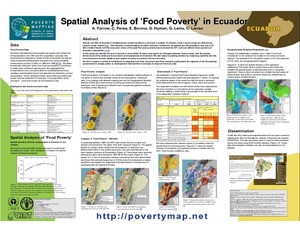
During the week beginning the 25th of October 1999 in Honduras and Nicaragua, Hurricane Mitch devastated large areas in the cities, razed bridges and highways, and left some regions isolated, blocking aid efforts. The production of basic grains that are obtained in the hillsides, where the poorest farrners live, suffered serious damage. Winds and floodwaters badly hit the productive areas where some farmers were harvesting their crops and others were planting. Great losses were caused, affecting the economy and production of food of these two countries.
Geosoil permite almacenar, consultar e interpretar información tanto del suelo como de su entorno biofísico a diferentes escalas: parcela, finca, comunidad, municipio, departamento, región, país. Opera a partir de una base de datos relacional elaborada en ACCES 2000, compuesta por una serie de tablas principales estructuradas con información a diferentes niveles jerárquicos que permiten la caracterización de las propiedades del suelo.