The datasets below have been drawn from a wide range of international data sources and cover an equally broad spectrum of land-related themes and issues. Use the different filters to begin mining this unique open data collection.
Afrobarometer Survey
Afrobarometer is a pan-African, non-partisan research network that conducts public attitude surveys on democracy, governance, economic conditions, and related issues in mo
Dataset provider:
Dataset provider:
ASTI - Agricultural Science and Technology Indicators (IFPRI/CGIAR/FAO)
The ASTI (Agricultural Science and Technology Indicators) dataset contains open-access data and analysis on agricultural research investment and capacity in low and middle-income countries. This information is fundamental to understanding the contribution of agricultural science and technology (S&T) to agricultural growth.
Dataset provider:
Dataset provider:
Bonn Challenge Barometer
The Bonn Challenge barometer quantifies the progresses towards the implementation of the Bonn Challenge (a global effort to bring 150 million hectares of defo
Dataset provider:
Dataset provider:
Commodities (Global Forest Watch)
Global Forest Watch (GFW) is an online platform with map viewer w
Dataset provider:
Dataset provider:
Community lands of Mozambique
The MADICO Geoportal (Mapeamento dos Direitos Comunitários, in Portuguese) serves as a centralized platform for accessing, managing, and sharing geospatial information related to community lands in Mozambique. It aims to provide a transparent and up-to-date repository of data on community land delimitations. The Geoportal is crucial for several reasons:
Dataset provider:
Dataset provider:
Corruption Perception Index (CPI)
The Corruption Perceptions Index (CPI) was established in 1995 by Transparency International as a composite indicator used to measure perceptions of corruption in the public sector in different countries around the world.
Dataset provider:
Dataset provider:
FAO - Agricultural Census
The FAO World Programme for the Census of Agriculture (WCA) published standardized and comparable statistics gathered in national agricultural censuses around the globe. The WCA is not only a dataset based on data aggregation. It is a system of support for conducting national agricultural census in more than 125 countries and territories.
Dataset provider:
Dataset provider:
FAO - Food Security
This dataset contains a suite of indicators (available from 2017) on the level of food security in several countries as provided by FAO.
Dataset provider:
Dataset provider:
FAO - Land and Gender
The Global Agenda for Sustainable Development spotlights land as a critical driver, and regional efforts reflect growing political support for women’s land rights. Indicators contained within the FAO Gender and Land Rights Database inform about the number and gender of agricultural land holders and owners, its value and area in female hands.
Dataset provider:
Dataset provider:
FAO - Land Use
This dataset contains more than 60 indicators concerning various aspects of land use (such as Country area, Agricultural land, Arable land, Forest land, Agricultural area certified organic, etc...) as provided by the Statistics Division of FAO.
Dataset provider:
Dataset provider:
FAO - Legal Assessment Tool
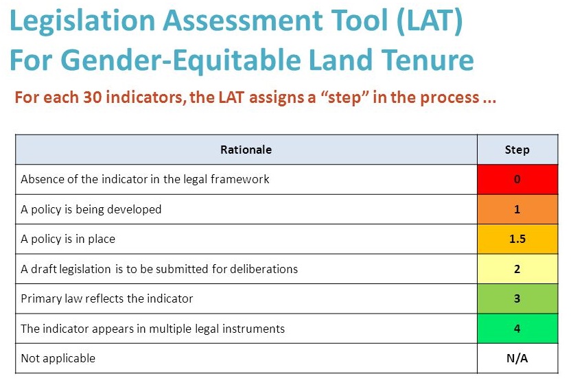
The Legal Assessment Tool (LAT) for gender-equitable land tenure was developed by FAO’s Gender and Land Rights Database (GLRD) for the purpose of providing prompt, targeted and effective policy advice and capacity development to FAO’s Member countries working towards gender-equitable land tenure.
Dataset provider:
Dataset provider:
FAO/ILRI - Global Livestock Production Systems in Rangelands
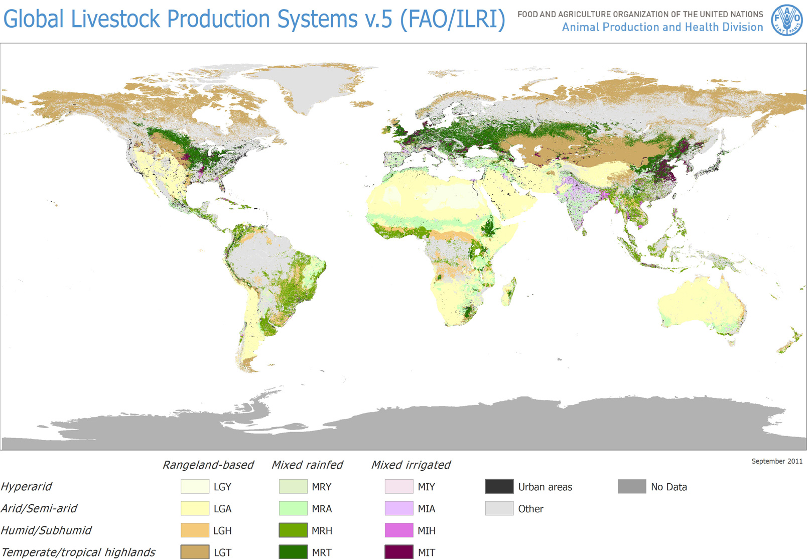
The dataset "Global Livestock Production Systems in Rangelands" presents a subset of data from the Map of Global Livestock Production Systems (version 5), a joint initiative between FAO and ILRI. It contains country-level indicators that measure the extension (in sq.
Dataset provider:
Dataset provider:
Global Corruption Barometer (GCB)
Transparency International’s Global Corruption Barometer is the most extensive worldwide public opinion survey on views and experiences of corruption.
Dataset provider:
Dataset provider:
Global Open Data Index - Land Ownership
This dataset contains the score and the ranking for the "Land Ownership" component of the Global Open Data Index (GODI) 2016/2017.
Dataset provider:
Dataset provider:
IFPRI - Global Hunger Index
This dataset contains the data used to calculate the Global Hunger Index (2019) for the years 2000, 2005, 2010 and 2019.
Dataset provider:
Dataset provider:
Intact Forest Landscapes
Intact Forest Landscape (IFL) are defined as “an unbroken expanse of natural ecosystems within the zone of current forest extent, showing no signs of significant human activity and large enough that all native biodiversity, includ
Dataset provider:
Dataset provider: