A tool for community-based water resources management in hillsides watersheds. Thesis (Ph.D.)

Journal Articles & Books
December, 1999
Colombia
Central America
South America
The introduction of web based mapping facilities that use satellite imagery, offers local people the possibility to map their environment. However, maps need to be accurate, which is the reason why map making is assigned to professionals. In this paper, we investigated the classification accuracy of road infrastructure from high resolution satellite imagery of an urban area in western Kenya achieved by surveyors and non-surveyors alike, with and without local knowledge. Those with local knowledge classified roads with over 92% accuracy on average, irrespective of surveying background.
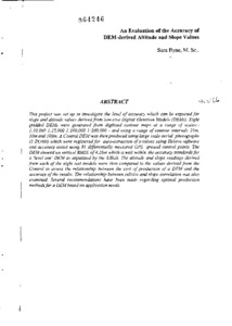
This project was set up to investigate the level of accuracy which can be expected for slope and altitude values derived from low-cost Digital Elevation Models (DEMs). Eight gridded DEMs were generated from digitized contour maps at a range of scales:1:10,000 1:25,000 1:100,000 1:200,000 - and using a range of contour intervals 25m, 50m and 100m. A Control DEM was then produced using large scale aerial photographs (1:28,000) which were registered for auto-extraction of z-values using Helava software and accuracy tested using 91 differentially measured GPS ground control points.