


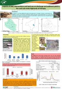
In the Blue Nile Basin of Ethiopian highlands, rainfall distribution is extremely uneven both spatially and temporally. Drought frequently results in crop failure, while high rainfall intensities result in low infiltration and high runoff causing soil erosion and land degradation. These combined…
Vast areas of forests in North‐eastern Ethiopia have been replaced by cropland, shrub land or grazing areas. Thus, information about how vegetation composition and structure varies with disturbance is fundamental to conservation of such areas. This study aimed to investigate the effects of…
This study analyzes urban expansion and the peri-urban land tenure security situation in Amhara National Regional State of Ethiopia, taking Bahir Dar and Debre Markos as case studies. To detect the extent of urban expansion, data from Landsat satellite images were analyzed using ERDAS IMAGINE,…
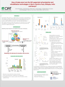
Soil quality (SQ) assessment from farmers' point of view can be used as a primary indicator for planning sustainable agriculture. Despite this fact, limited information is documented with regard to SQ indicators, for example weed species, crop types and management practices from farmers…
Sediments deposited by (paleo) flash floods can hold valuable information on processes of environmental change, land degradation or desertification. In order to assess the suitability of flash flood deposits as proxies for land degradation, we monitored a representative gully segment in North…
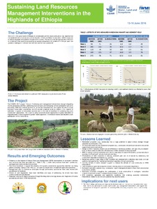
Understanding changes in soil quality resulting from land use and land management changes is important to design sustainable land management plans or interventions. This study evaluated the influence of land use and land cover (LULC) on key soil quality indicators (SQIs) within a small watershed…
This paper illustrates how the capabilities of GIS and satellite imagery can be harnessed to explore and better understand the urban form of several large African cities (Addis Ababa, Nairobi, Kigali, Dar es Salaam, and Dakar). To allow for comparability across very diverse cities, this work…