
page search

There are 1, 166 content items of different types and languages related to geographical information systems on the Land Portal.
Displaying 1 - 12 of 578

Land-use/land-cover dynamics in Chiang Mai: Appraisal from remote sensing, GIS and modelling approaches

April, 2006

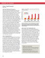
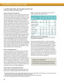
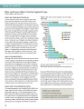
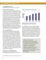
Remotely-sensed images and Geographical Information Systems (GIS) data were integrated into the SLEUTH cellular automata (CA) model to analyze land-use/land-cover dynamics in Chiang Mai city and its surrounds. The land-use and land-cover statistics, obtained from GIS data base and satellite images from 1952, 1977, 1989 and 2000 revealed rapid increased in urbanization during these periods. To understand the underlying causes of land-use and land-cover dynamics, remote sensing, GIS and modeling techniques were applied.

Roads, lands, markets, and deforestation: a spatial model of land use in Belize

December, 1994

Will intensifying the road network around market areas produce greater economic returns and less environmental damage than extending the road network into new areas?Rural roads promote economic development but also facilitate deforestation. To explore the trade-offs between development and environmental damage posed by road building, Chomitz and Gray develop and estimate a spatially explicit model of land use.

Decision Support System (DSS) for sustainable watershed management in Dong Nai Watershed - Vietnam

December, 2004

In this study, DSS was developed using linear programming (LP), goal programming (GP), and geographic information system (GIS) for sustainable watershed management in Dong Nai watershed, Vietnam. A case study approach was undertaken using `what-if` planning scenarios. The multi-objective linear programming (MOLP) techniques and GIS have been applied to display the optimum land resource allocation in different scenario, in order to evaluate the sustainable strategy of land development in a watershed.

Assessing the stream water quality dynamics in connection with land use in agricultural catchments of different scales

June, 2008
Czech Republic

We introduce a simple method for estimating the changes of nitrate concentrations in surface waters regarding the land use modification. Stream and drainage water nitrate concentrations in prevailingly agricultural catchments of three different scales located in the Crystalline complex of the Czech massif, Czech Republic, were included in this study. Water quality samples were collected through the years 1992-2006 at monthly and bi-monthly intervals.

BALTIC SURVEYING PROCEEDINGS OF SCIENTIFIC METHODICAL CONFERENCE „BALTIC SURVEYING’14”

Reports & Research
December, 2013
Latvia
Kazakhstan

This article deals with the theoretical issues of land resources evaluation, land fund structure, problems and directions of rational use of land resources in the Republic of Kazakhstan.

Authors:
Dzhulamanov, T., Kazakh National Agrarian Univ., Almaty (Kazakhstan)
Pentaev, T., Kazakh National Agrarian Univ., Almaty (Kazakhstan)
Igembaeva, A., Kazakh National Agrarian Univ., Almaty (Kazakhstan)
Abaeva, K., Kazakh National Agrarian Univ., Almaty (Kazakhstan)

Cereal crops

Peer-reviewed publication
December, 2014
Eastern Africa
Western Africa
Southern Africa
Sub-Saharan Africa
Africa