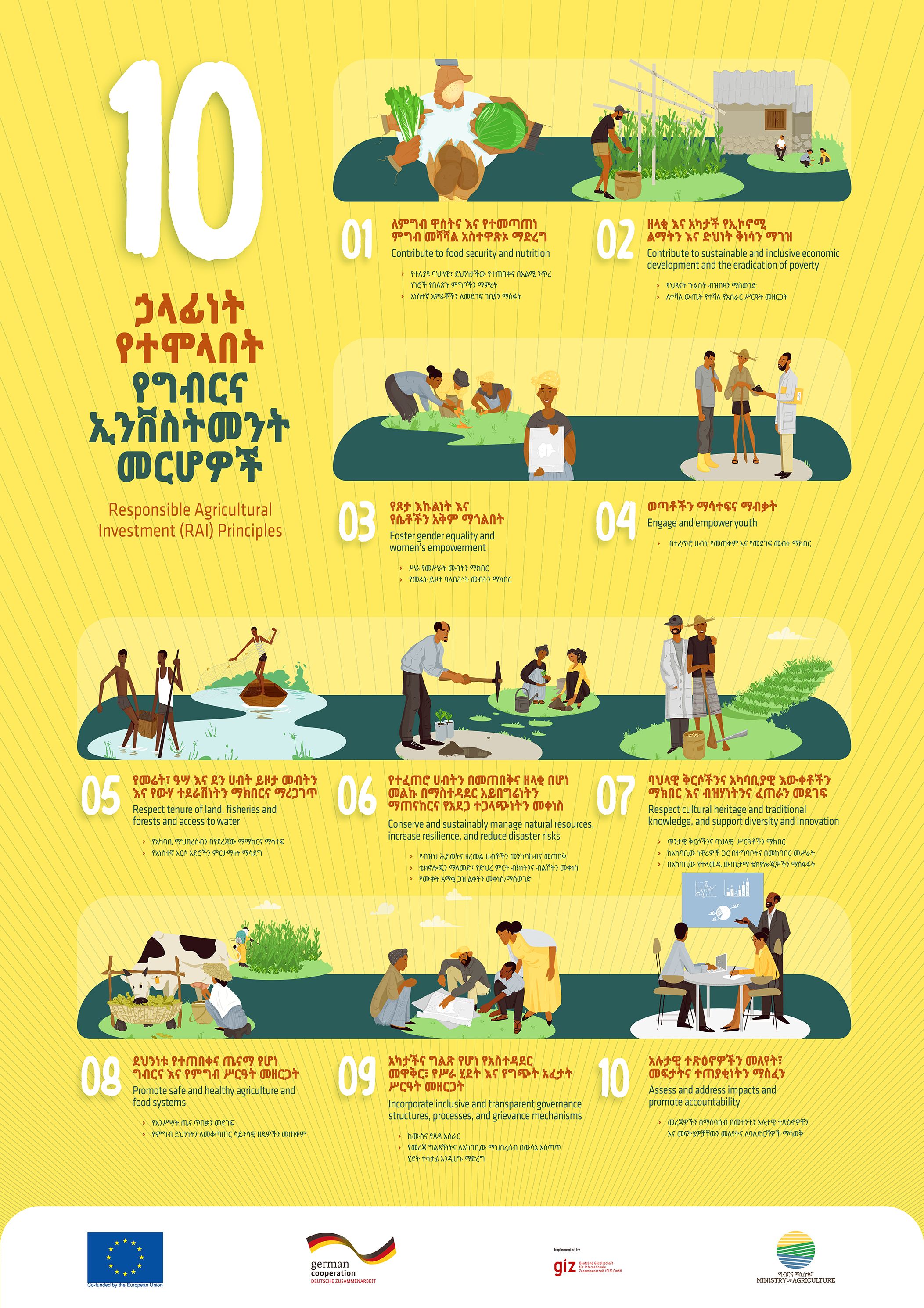
Responsible Agricultural Investment 10 Principles Poster (Amharic and English)
Maps
October, 2023
Ethiopia
A poster highlighting the10 Resonsible Agricultural Investment Principles
For a topic as land governance maps are an extremely important tool. Many organizations and information providers have visualized land-related data in the form of maps, whether they are pictures or advanced geospatial maps. The metadata about and links to these maps are included in this subcategory of the Multimedia-resource type.
A poster highlighting the10 Resonsible Agricultural Investment Principles
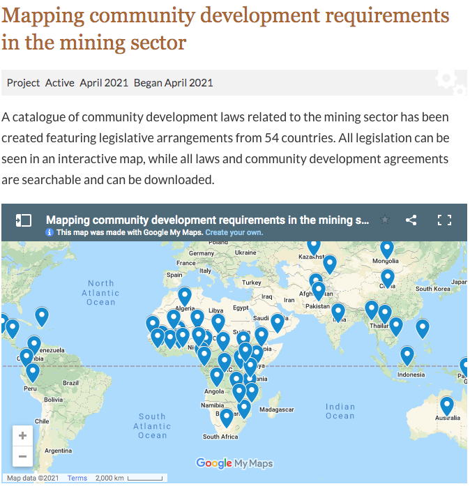
IIED, the Sustainable Development Strategies Group (SDSG) and the Columbia Center on Sustainable Investment (CCSI) have created a collection of community development laws for the mining sector to encourage and facilitate better research and policy. The resource, with all community development laws available to search via the map above and all legislation and agreements in the list below, includes relevant legislation from 54 countries. All documents are available to download in PDF format.
Landscope is a system for measuring tenure risk, a term created to describe the financial risk associated with local opposition to a real asset. This kind of opposition to investments is very common across Africa, Asia and Latin America, often causing significant financial losses and operational headaches. It applies a new approach to analysing geospatial data about social, environmental and political issues that is designed to help companies and investors in emerging and frontier markets to prepare a proper assessment of tenure risk at project, supply chain or portfolio level.

This map shows Drylands found in Rangelands (using global aridity classes) mapped against country boundaries providing approximate areas of Drylands found in rangelands per country. Aridity zones were derived from an Aridity Index (AI) which is calculated as the ratio of precipitation to potential evapotranspiration. Zones included in this dataset are: hyperarid, arid, semiarid, and dry subhumid. These are in accordance with the United Nations Convention to Combat Desertification (UNCCD) definition of Drylands and previously mapped by UNEP-WCMC 2007.
This map shows global aridity classes mapped against country boundaries providing approximate areas of drylands per country. Aridity zones were derived from an Aridity Index (AI) which is calculated as the ratio of precipition to potential evapotranspiration. Zones included in this dataset are: hyperarid, arid, semiarid, and dry subhumid.These are in accordance with the United Nations Convention to Combat Desertification (UNCCD) definition of Drylands and prevously mapped by UNEP-WCMC 2007. Country boundaries were taken from ESRI 2016.
This map shows global historic" Anthropogenic Biomes" of the world (as mapped by Ellis et al 2000) that exists within rangelands, selected classes are: Pastoral Villages, Residential Rangelands, Populated Rangelands and Remote Rangelands. The mapping of the rangelands is taken from rangeland types and boundaries previously mapped by University of Idaho and the Society for Rangeland Management (SRM). Country boundaries were taken from ESRI 2016.
This map shows global ruminant production system that exists within rangelands. Selected classes are: LGY (Livestock-only systems in Hyper Arid areas), LGA (Livestock-only systems in arid areas), LGH (Livestock-only systems in humid areas) and LGT (Livestock-only systems in temperate areas or Tropical Highlands). The mapping of global ruminant production systems was undertaken by FAO and ILRI. The mapping of the rangelands is taken from rangeland types and boundaries previously mapped by University of Idaho and the Society for Rangeland Management (SRM).
This map shows rangelands globally per country based on categorization of all 867 ecoregions in the TEOW(Terrestrial Ecosystems of the World) using the definitions of rangeland ecotypes and non-rangeland ecotypes, providing approximate areas of rangelands per country. This map classifies rangelands into four rangeland ecotypes (grasslands, shrublands, savanna/woodland, and tundra) and combines non-rangeland ecotypes into one 'other' layer. Rangeland types and boundaries were previously mapped by University of Idaho and the Society for Rangeland Management (SRM).
This map shows terristrial protected areas found within rangelands. The information on protected areas is taken from IUCN and UNEP-WCMC World Database on Protected Areas. The mapping of the rangelands is taken from rangeland types and boundaries previously mapped by University of Idaho and the Society for Rangeland Management (SRM). Country boundaries were taken from ESRI 2016.

By Tim Fella, Land Tenure and Conflict Advisor, USAID. On October 15, I had the honor of presenting an updated version of the Global Donor Working Group on Land’s program database and map at a side event at the 41st plenary of the UN Committee on World Food Security (CFS).