Spatial analysis of intraspecific diversity: a point-centred approach
Reports & Research
December, 1997

Spatial patterns in socioeconomic data reveal issues and trends that would otherwise be missed by data aggregation to political or other units. Geographic Information System (GIS) tools provide display and analysis capabilities that are underutilized by many social scientists. The present article combines field-based surveys that maintain locational information with GIS tools to examine gender roles, responsibilities, and workloads in a spatial context for a case-study watershed in Nepal. Adult women outworked men by an average of 3.8 hours per day.
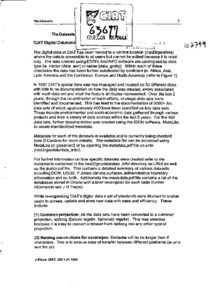
Although soil fertility is recognized as a primary constraint to agricultural production in developing countries, use of fertilizer in Sub-Saharan Africa is declining. Smallholder farmers still rely heavily on livestock manure for soil fertility management. To explore the determinants of soil fertility management practices, including both the use of cattle manure and inorganic fertilizer, data are used from a sample of 3,330 geo-referenced farm households across Central and Western Kenya. A bivariate probit model is applied to jointly examine the use of the two technologies.
Amidst the economic backdrop of resource-poor farmers, combined research and extension efforts in developing countries have focused on developing and promoting potentially adaptable and economically acceptable agronomic technologies that suit farmers situations. Practices like improved fallows with woody and herbaceous legumes (e.g. Canavalia sp., Crotalaria sp.,Mucuna sp., Lablab sp., and Tephrosia sp.) are considered an appropriate approach to improving soil fertility management and an alternative to expensive, and often not available, inorganic fertilizers.

Over the last years, geospatial web platforms, social media, and volunteered geographic information (VGI) have opened a window of opportunity for traditional Public Participatory GIS (PPGIS) to usher in a new era. Taking advantage of these technological achievements, this paper presents a new approach for a citizen-orientated framework of spatial planning that aims at integrating participatory community work into existing decision-making structures.
Governments in many countries are decentralising to give more control over decision making and budgets to local administrations. One expectation of this change is that local governments will more effectively and efficiently respond to the poorest citizens in their jurisdictions. Decentralisation is especially significant to forest communities, which have historically benefited little from government services and poverty reduction programmes because of their physical isolation and social marginalisation.
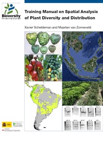
This training manual is intended for scientists and students who work with biodiversity data and are interested in developing skills to effectively carry out spatial analysis based on (free) GIS applications with a focus on diversity and ecological analyses.
These analyses offer a better understanding of spatial patterns of plant diversity and distribution, helping to improve conservation efforts. The training manual focuses on plants of interest for improving livelihoods (e.g. crops, trees and crop wild relatives) and/or those which are endangered.
Improved understandings of the agricultural and range ecologies of semi-arid Africa require better information on the spatiotemporal distribution of domestic livestock across agropastoral landscapes. An empirical GIS-based approach was developed for estimating distributions of herded livestock across three agropastoral territories (around 100 km2 each) over a two-year period.